Commercial Area
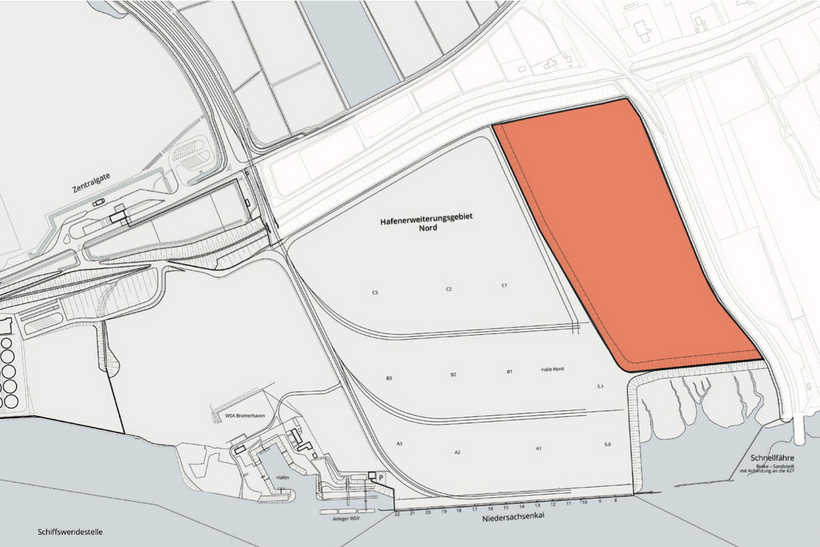
Golzwarden – northern part

Address
Port Area of Brake
Nordstraße
26919 Brake
Object
- abt. 13 ha undeveloped surface area
- the terrain is safe from high water flooding
- heavy cargo transshipment up to 1,000 metric tons possible
Availability / type of contract
- entire area available immediately
- area can be made available as total area or in parcels
- building lease contract, optional lease contract
Commercial utilization / zoning plan
- SO-Port as per zoning plan B69
Land use and zoning plan / construction
- cubic index 8.0-10.0 / site coverage 0.8
Limitations
- the height of building facilities is restricted to an overall height of 15 m
Target businesses
- cargo handling related usage, port services
Road connection
- Nordstraße
- federal motorway B 212/B211
- Autobahn »federal motorway system« access via Weser Tunnel to A27 abt. 15 km
Rail connection
- existing
Quay facility
- Niedersachsenkai
- quay length 450 m
- permissible draft 11.90m, after planned dredging adjustment of the Weser: 12.80m
- superstructure: 2 gantry cranes, hoisting capacity 60 metric tons; 2 mobile cranes, hoisting capacity 140 metric tons
Downloads
Charcteristics
Object :
B03
Size :
abt. 13 ha
Buildings :
undeveloped
Availibility :
immediately
Exploration :
road, port rail, Niedersachsen Quay
Usage :
cubic index 8.0-10.0 / site coverage 0.8
Distances
| Airport (HB). | abt. 60 km |
| City center | abt. 2,5 km |
| Bremen | abt. 60 km |
| Bremerhaven | abt. 40 km |
| Hamburg | abt. 185 km |
| Hannover | abt. 190 km |
| Duisburg | abt. 280 km |

