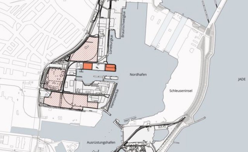
Commercial Area
Nordhafen (North Port)

Address
Port Wilhelmshaven
Friesendamm / Jachmannbrücke
26384 Wilhelmshaven
Object
- abt. 17 ha (thereof 15 reserved) vacant area in the Nordhafen
- right on the tide free Innenhafen (Interior Port)
- the total area can be subdivided
Availability / type of contract
- available immediately
- lease or Erbpacht contract
Commercial utilization / zoning plan
- special port area acc. to zoning plan
Land use and zoning plan / construction
- site coverage 0.8
- cubic index 9.0
Limitations
- max. building height 65 m
- no industries, processing or handling goods that raise dust such as sand, gravel or other soils
Target businesses
- cargo handling driven usages, port services, services providers, offshore technology
Road connection
- Friesendamm / Jachmannbrücke
- connection to Autobahn A 29 abt. 5 km
Rail connection
- no direct rail access
- Sande 13 km
Quay facility
- Braunschweig quay 320 m (draft 12 m)
- Hannover quay 325 m (draft 11 m)
- Lüneburg quay 275 m (draft 11 m)
Downloads
EU-Ausschreibung
Charcteristics
Object :
W01
Size :
18 ha
Buildings :
undeveloped surface
Availibility :
immediately
Exploration :
developed
Usage :
special port area
Distances
| Airport (Mariensiel) | abt. 10 km |
| City center Wilhelmshaven | abt. 5 km |
| Bremen | abt. 100 km |
| Bremerhaven | abt. 75 km |
| Hamburg | abt. 121 km |
| Hannover | abt. 220 km |
| Duisburg | abt. 340 km |
